


4:25 Update
Overview/What's New: The leading line of storms has exited our area with lingering showers and embedded thunderstorms. A cold front will move through this evening, and another line of storms will move through the area as this front swings through. Based on current observations, the trends, and the hi-resolution guidance, our main concerns heading into tonight are non-thunderstorm winds and the potential for additional flooding. Please see below for specifics on each hazard.
*Impact 1 - Redevelopment of Thunderstorms *
*Impact 2 - Flooding*
*Impact 3 - Non-Thunderstorm Winds*
The coastal and marine impacts have not changed from previous forecasts, and we still have a High Surf Warning, a High Risk for Rip Currents, a Coastal Flood Advisory, and a Gale Warning in effect.
________________________________
3:50 p.m. Update
The NWS has cancelled the tornado Watch for Okaloosa County. Okaloosa Public Safety is now monitoring for any redevelopment potential this evening and the river level forecasts.
______________________
1:40 p.m. Update
The National Weather Service in Mobile has issued a
* Severe Thunderstorm Warning for...
Southeastern Escambia County in south central Alabama...
Southwestern Covington County in south central Alabama...
Okaloosa County in northwestern Florida...
Santa Rosa County in northwestern Florida...
Eastern Escambia County in northwestern Florida...
* Until 230 PM CDT.
*****Okaloosa County non-essential operations are closed for the day.****
Departments which employ essential employees in Public Safety, Corrections, Public Works, Water and Sewer, Airports and other time-sensitive, critical functions will continue to operate a duty schedule determined by their Department Director in order to avoid interruptions in service.
_______________________
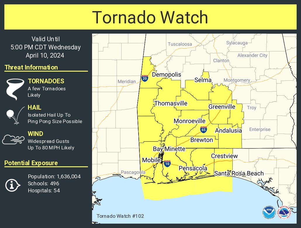
10:24 a.m. Update ( April 10, 2024)
The National Weather Service in Mobile has issued Tornado Watch for portions of northwest Florida from now until 5p.m. This Watch impacts the following locations: Escambia, Okaloosa, and Santa Rosa Counties.
___________________________________
(9 a.m. -Wednesday - April 10, 2024)
Okaloosa Public Safety and NWS Weather Update ( 9 a.m. -Wednesday - April 10, 2024)
Today’s upcoming weather system will bring heavy rains to the area which could lead to flash flooding.
Okaloosa County is closely monitoring the evolving situation in close coordination with the National Weather Service, Florida Division of Emergency Management, strategic partners and neighboring counties. We are not activating risk shelters at this time as school is in session. Please have multiple ways to receive emergency information and monitor official new sources. The Okaloosa County Emergency Operations Center will be activated to Level 2 at noon, staffed with Command-level personnel and our Public Information Officer to assist in operating command and control elements as well as monitoring and disbursing information on the storm and any local impacts.
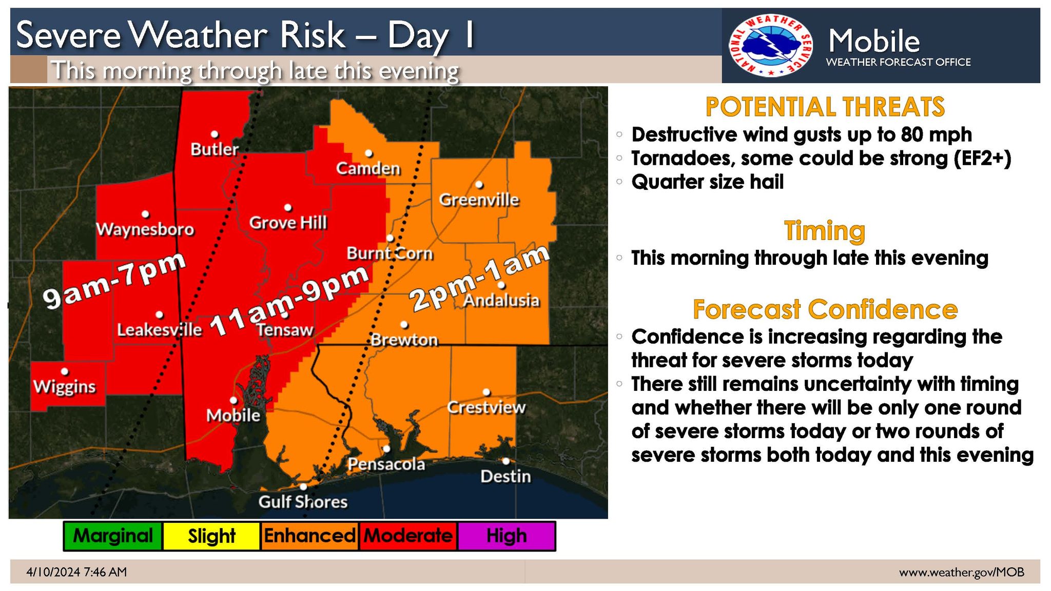
Severe weather is expected but there are two plausible scenarios:
• Scenario #1: A squall-line moves across the forecast area from west to east from mid-morning through late afternoon. In advance of the squall-line, a few discrete supercells will be possible across far southeast Mississippi and potentially as far east as coastal Alabama. Damaging winds up to 80 mph and tornadoes will be possible with any supercell and within the squall-line.
• Scenario #2: The squall-line poses a threat for damaging winds and tornadoes across southeast Mississippi but weakens as it moves into Alabama and transitions to a flood threat north of the I-10 corridor. Across coastal Alabama and the Florida Panhandle, the severe weather threat would be this evening into the overnight hours with a tornado and damaging wind threat.
Sign up for local weather alerts at AlertOkaloosa.com
The latest local severe weather information from the County can be found on social media at https://www.facebook.com/OkaloosaCounty/ or on the County’s EOC website at https://myokaloosa.com/eoc/home
Debris Info as of 9 a .m. April 10, 2024
Unless there is an emergency declaration related to debris recovery, it will be business as usual related to garbage service. Same rules apply to bulk waste and yard trash for routine residential service:
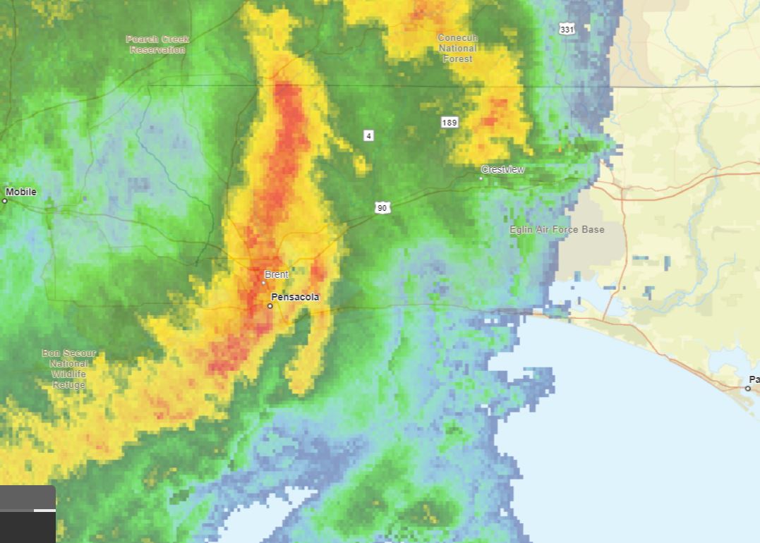
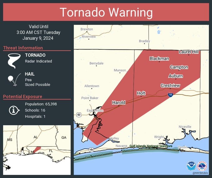
6:30 a.m. - NWS - Tornado Warning until 7 a.m. for portions of Okaloosa County.
______
5:30 a.m. Jan. 9
![]() NWS (Weather.gov/mob): Severe Thunderstorm Warning until 6:30 AM CST
NWS (Weather.gov/mob): Severe Thunderstorm Warning until 6:30 AM CST
The main line of storms is now entering Florida, moving East. Very quick tornadic spinups have occurred in this system with 70MPH straight-line winds embedded in the line. We’re hoping that the line is East of Okaloosa County by 7:30-8AM. Take appropriate precautions now.
Per OCSO as of 5:43 a.m. Hwy 285 is back open.
Per OCSO: Hwy 285 at State Road 293 completely shut down for road debris from the storm.
2:45 a.m.
Jan. 8, 2024 (9:06 p.m)
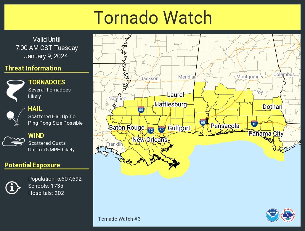
🌪️A tornado watch has been issued for parts of Alabama, Florida, Louisiana and Mississippi until 7 AM CST 01.09.2024.
____________________________________
Jan. 8, 2024 ( 2:30 p.m.)
Okaloosa County will be activating the Emergency Operations Center at midnight, Jan. 9, 2024, to a modified Level 2 (partial activation) in preparation for potential severe weather that is forecast to impact the County. Emergency Management staff will be monitoring the storm system that is expected to bring sustained winds of 25-30 mph with possible gusts above 70 mph.
Additionally, County administrative offices will be opening on a delayed start on Tuesday, January 9, to ensure the safety of employees during potentially hazardous conditions in the morning. Departments deploying essential personnel will follow a schedule set by the Department Director to maintain continuity of operations.
The main line of storms is expected to arrive between 6- 7 a.m. on Tuesday and clear by 9 a.m. Heavy rainfall of 2-3 inches is forecast with the possibility of tornadoes.
Residents are encouraged to take this system seriously and make preparations that include securing loose debris around the home, having multiple ways to stay informed, and being prepared for the possibility of power outages.
The latest local severe weather information from the County can be found on social media at https://www.facebook.com/OkaloosaCounty/ or on the County’s EOC website at https://myokaloosa.com/eoc/home
302 N. Wilson St. - Suite 302
Crestview, FL 32536
1250 N. Eglin Parkway, Suite 100
Shalimar, FL 32579
Call 850-689-5050 or 850-423-1542 for all departments.
Copyright © 2015 Okaloosa County, Florida. All rights reserved.
