


Click HERE to sign up for local alerts | DOWNLOAD the Hurricane Guide
4pm TROPICAL STORM FRED made landfall near Cape San Blas about an hour ago with max sustained winds of 65 MPH and is now moving North/Northeastward with winds of 60 MPH. The storm has come as far West as it was going to go and is peeling away from Okaloosa County.
Noon Live Update with Public Safety Director Patrick Maddox
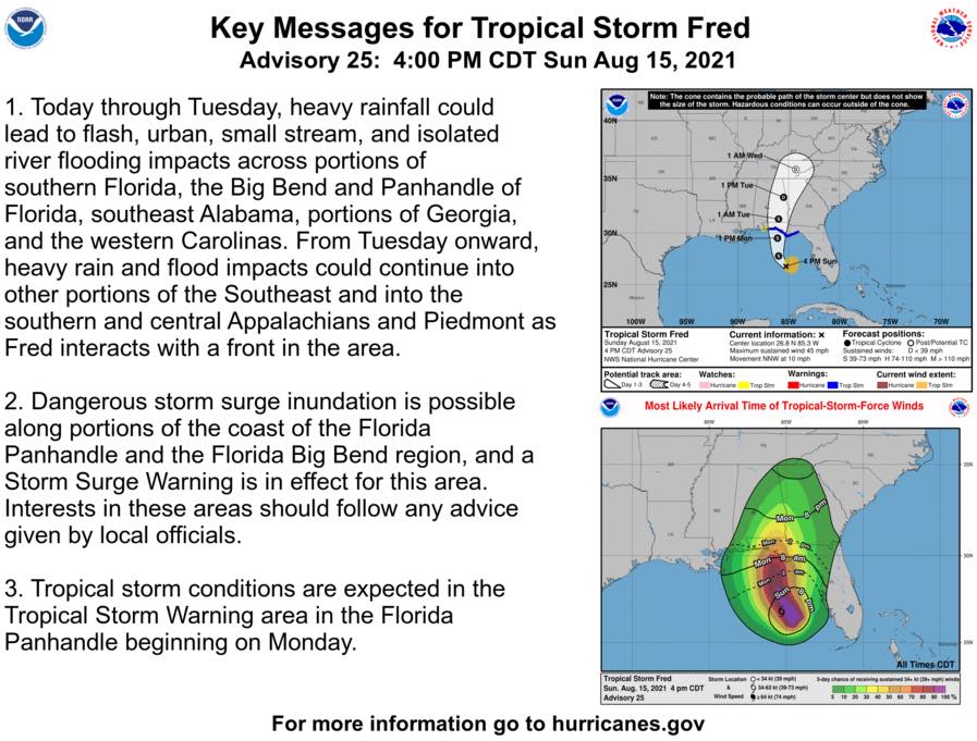
11am Tropical Storm Fred (Monday midday update) from Okaloosa County Public Safety, National Weather Service and National Hurricane Center. Tropical Storm conditions are beginning now, surge warnings from Indian Pass to Yankee town 3-5 feet (East of our area), 1-3 feet for us (also diminishing since high tide has passed), 2-4” rain throughout the county which is a nice shift downward. Fred is expected to be a strong Tropical Storm at landfall. The threat of sustained tropical storm force winds is decreasing, but gusts to tropical storm force (mostly 25-35MPH) are certainly possible.
◾Rain: 3-4" of rain forecast ◾On the forecast track, the center of Fred should make landfall in the eastern Florida Panhandle this afternoon or early this evening, and move over western Georgia on Tuesday. ◾Wind gust of 25-35 possible beginning this afternoon through this early to mid this evening (mostly gusts) ◾Surf heights to build between 6-9 feet. ◾Bridges: FDOT and local law enforcement consider closing bridges only when sustained winds reach 40 mph
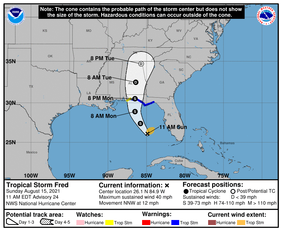
National Hurricane Center 10 a.m. Fred information:
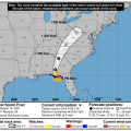
- LOCATION ABOUT 55 MI SW OF APALACHICOLA FLORIDA
- MAXIMUM SUSTAINED WINDS 60 MPH
- PRESENT MOVEMENT N OR 10 DEGREES AT 10 MPH
- MINIMUM CENTRAL PRESSURE 993 MB
10:30 - TURN AROUND DON’T DROWN - While we may see some elevated sustained winds, our area of greatest concern is going to be ponding water and flash flooding as rain bands make their way onshore. 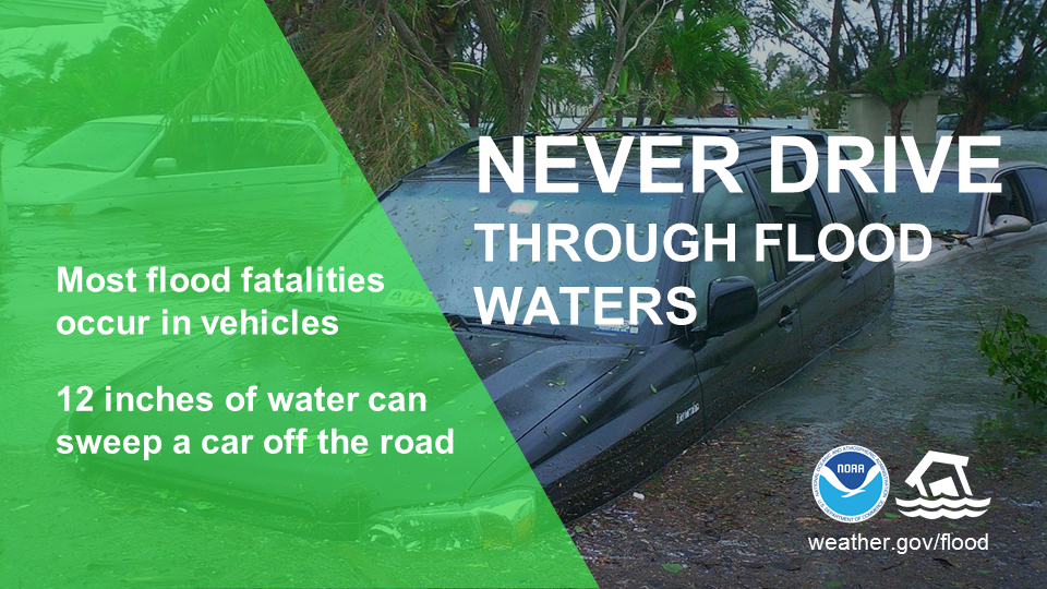 DO NOT DRIVE THROUGH FLOODED OUT AREAS. STAY INDOORS DURING DOWNPOURS. County offices are closed. Courts are closed. Schools are closed.
9:30am - Double Red Flags on Okaloosa County Beaches. Stay Completely out of the water. Follow local alerts and advosories at AlertOkaloosa.com.
8:30am - TROPICAL STORM FRED UPDATE (Monday 8:30 a.m.) Tropical Storm Fred has intensified and is tracking further east of Okaloosa County. This is again beneficial for Okaloosa and nudges tropical storm force wind probabilities and rainfall down a bit. 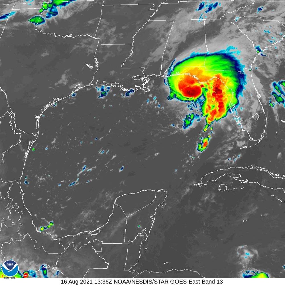
Data from an Air Force Reserve Hurricane Hunter aircraft indicate that Fred is intensifying this morning, and now has maximum sustained winds near 60 mph with an estimated minimum central pressure of 993 mb, according to the National Hurricane Center. A Storm Surge Warning and Tropical Storm Warning is still in effect for the Panhandle to include all of Okaloosa County. 7:30 a.m. data from NHC: LOCATION ABOUT 80 MI SSW OF APALACHICOLA FLORIDA - MAXIMUM SUSTAINED WINDS 60 MPH - PRESENT MOVEMENT N OR 10 DEGREES AT 10 MPH - MINIMUM CENTRAL PRESSURE 993 MB
Remember to stay tuned to local media. We'll provide regular updates. The following are great sources for weather news: - weather.gov/mob - https://www.nhc.noaa.gov/ - https://alertokaloosa.com/
7:30pm Tropical Storm Fred update. Jogs to the east place landfall near the Walton County/Bay County line. This brings us out of the highest rainfall values and places us in the 3-6” range if this track holds. This is beneficial for us in many ways, but flash flooding/minor urban flooding can still occur based on rainfall rate alone.
Moderate flooding along the Blackwater and Shoal Rivers is still forecast for Tuesday and Wednesday. We still expect to see some tropical storm force winds throughout the county, mainly along the coast, but gusts to that strength are certainly possible in the North end as well. Any attempt at more organization may allow Fred to wrap more moisture immediately around its core which could change those values some. Storm surge remans at 1-3 feet for our area. Our Local State of Emergency is executed, schools are closed tomorrow AM in an abundance of caution as roadway conditions and unknown bridge status depending on wind are concerns. Risk shelters and evacuations are not anticipated at this time, though a special shelter is on standby for any river evacuees if necessary. Only those designated as essential county employees are to report to work tomorrow. Contact your supervisor if you have questions on the designation of your position. EC Rider has suspended regular bus service tomorrow. Tropical Storm Grace is right behind Fred, but at least for the moment, seems to be staying South. We will monitor closely.Stay tuned for further and monitor hurricanes.gov.

◾A Tropical Storm Warning is now in effect for the coast of the Florida Panhandle from Navarre to the Wakulla/Jefferson County line which includes all of Okaloosa County.
◾ Get prepared for this storm with resources in this link: https://business.facebook.com/1545370005699157/posts/3116989405203868/
The track shifted farther east with landfall now projected in Okaloosa County on Monday evening. Although the chances for tropical storm force winds have risen into the 56%-61% range, the chances for experiencing the heaviest rainfall are decreasing some, with much of the county in the 4-6” range and the eastern third in the 6-8" range. These values can change with track adjustments. Earliest estimated arrival of tropical storm winds, if they were to occur, would be 6 a.m. Monday morning, but changes in the track can push that timing north or south as well. Only minor coastal flooding of 1-3 feet is forecast, but the potential for flash flooding exists with rapid rainfall. Fred is still forecast to a 50 mph tropical storm upon landfall.
◾A Storm Surge Warning has been issued for the coast of the Florida Panhandle. Surge of 1-3 feet is expected.
◾Sandbags available at the following locations while supplies last: -714 Essex Road in the Ocean City-Wright area at Stillwell Park -1759 South Ferdon Boulevard – access off of Goodwin Avenue across from the fuel tanks
◾Bridge closures can be expected when sustained winds exceed 39 mph and closures will be decided by FDOT and local law enforcement.
NHC 10 a.m. storm status update: - ABOUT 335 MI SSE OF PENSACOLA FLORIDA - MAXIMUM SUSTAINED WINDSn40 MPH - PRESENT MOVEMENT NNW AT 12 MPH - MINIMUM CENTRAL PRESSURE 1008 MB. Remember to stay tuned to local media. We'll provide regular updates. The following are great sources for weather news:
- weather.gov/mob
STORM KIT: Be sure you have a storm kit prepared. The first 72 are on you, meaning that you should have prescriptions, water, food, don't forget the pet food, batteries and flashlights. It doesn't take a major hurricane to cause an impact to our modern necessities. View a full list of storm kits items at: https://myokaloosa.com/ps/severe-weather/supply-kit SANDBAGS (While supplies last) Okaloosa County Public Works will make sandbags and sand available for self-serve pick-up beginning at 8 a.m. Friday August 13 at the following locations:-714 Essex Road in the Ocean City-Wright area at Stillwell Park-1759 South Ferdon Boulevard – access off of Goodwin Avenue across from the fuel tanks. The sites will be accessible 24 hours a day while supplies last or until the threat of the storm has passed. Should you have any questions regarding the location of the sandbag sites, please feel free to contact Public Works at 850-689-5772.LAWN FURNITURE. DEBRIS. TRASH.Now is a great time to find a safe shelter for patio and lawn furniture... Actually, anything you'd like to keep from blowing around risking danger to family and property. Looking to pitch in a little more to help others? Visit http://myokaloosa.com/bcc/leavenotrace to find community-organized cleanup efforts.We hope you’ve prepared in advance for hurricane season as placing yard debris on the curb in advance of a storm is not a good plan. Placing excessive yard debris or bulk waste on the curb days before a weather event can cause hazardous objects to blow around.
For more information on how to prepare, CLICK HERE to download our hurricane guide.
FOR MORE INFORMATION CLICK HERE TO SIGN UP FOR ALERTS
302 N. Wilson St. - Suite 302
Crestview, FL 32536
1250 N. Eglin Parkway, Suite 100
Shalimar, FL 32579
Call 850-689-5050 or 850-423-1542 for all departments.
Copyright © 2015 Okaloosa County, Florida. All rights reserved.
