


April 5-6, 2022
4.6.22 3pm:
The NWS is keeping us in the Slight Risk category for any storms which are able to fire this afternoon and evening. So far not much activity, but we will continue to monitor. There’s plenty of MLCAPE (instability in the atmosphere) but not a ton of deep level shear at the moment so the tornado risk is quite a bit lower than yesterday. This type of set up favors gusty winds and hail if the storms are able to sustain themselves. As the cold front approaches there is an opportunity for the deep level shear to increase, so we’ve got our eye on it. Overview/What's New: There remains the possibility of isolated severe thunderstorms this afternoon and evening with large hail and damaging wind gusts the main threats.
4.5.22 - 2p.m.
4.5.22 - 1:40 p.m.
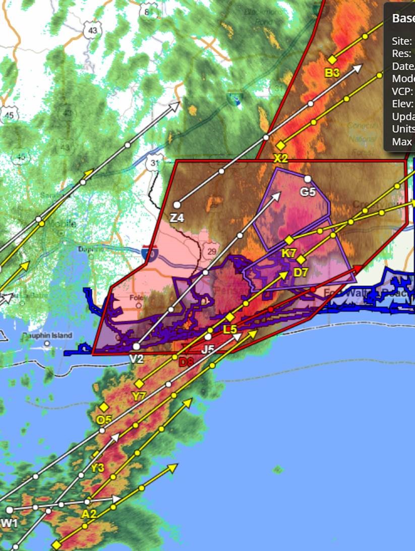
The National Weather Service In Mobile Has Issued A
* Flash Flood Warning For...Southeastern Okaloosa County In Northwestern Florida...* Until 745 Pm Cdt Tuesday.
* At 137 Pm Cdt, Doppler Radar Indicated Thunderstorms ProducingHeavy Rain Across The Warned Area. The Expected Rainfall Rate Is 1
To 3 Inches In 1 Hour. Additional Rainfall Amounts Of 1 To 4 Inches Are Possible In The Warned Area. Flash Flooding Is OngoingOr Expected To Begin Shortly.
Impact...Flash Flooding Of Small Creeks And Streams, uban Areas, highways, streets and underpasses as well as Other Poor Drainage And Low-Lying Areas.
* Some Locations That Will Experience Flash Flooding Include...Wright, Fort Walton Beach, Niceville, Destin, Eglin Afb, Valparaiso, Mary Esther, Lake Lorraine, Ocean City, Shalimar,
Cinco Bayou, Eglin Village, Longwood, Postil And Seminole.
4.5.22 - 1:30 p.m.
The National Weather Service in Mobile has issued a
* Severe Thunderstorm Warning for...
Southern Okaloosa County in northwestern Florida...
Southeastern Santa Rosa County in northwestern Florida...
* Until 200 PM CDT.
* At 120 PM CDT, severe thunderstorms were located along a line
extending from 5 miles south of Crestview to 3 miles northeast of
Navarre Beach, moving east at 45 mph.
HAZARD...70 mph wind gusts.
SOURCE...Radar indicated.
IMPACT...Expect considerable tree damage. Damage is likely to
mobile homes, roofs, and outbuildings.
* Locations impacted include...
Wright, Fort Walton Beach, Niceville, Destin, Eglin AFB,
Valparaiso, Mary Esther, Ocean City, Lake Lorraine, Shalimar, Cinco
Bayou and Navarre Beach.
PRECAUTIONARY/PREPAREDNESS ACTIONS...
A Tornado Watch remains in effect until 200 PM CDT for northwestern
Florida.
For your protection move to an interior room on the lowest floor of a
building.
A Tornado Watch remains in effect until 200 PM CDT for northwestern
Florida.
4.5.22 - 12:30 p.m.
The northwestern areas of the County will be impacted by the storm system shortly, followed by the remainder of the county from NW to SE as the line passes through.
Watches/Advisories
-Tornado Watch in effect until 2 p.m.
-Severe thunderstorm warning until 1:15 p.m. (60 mph gusts - radar indicated)
-Wind Advisory in effect until 6 p.m. (sustained winds 15-25mph with gusts of 40 mph or more)
-Small craft advisory
-Gulf water is closed for swimming (double red flags are flying at the beach)

4.5.22 8:30am SEVERE WEATHER UPDATE - There are no changes to the impacts for Today's event. There is a slight adjustment to delay the squall line timing by a couple of hours, and extend the timing through 6pm. We still expect two rounds of severe weather today and those details are broken down in the bulleted points below. A Tornado Watch is now in effect for the entire area until 2pm. Additional watches will be possible later today. A High Surf Advisory has been issued for this Afternoon and Evening for expected breaker heights of 5 to 6 feet. Minor coastal flooding is still a possibility in the northern portion of Mobile Bay in the mid to late afternoon hours (potentially impacting the Causeway near the eastbound I-10 onramp). A High Risk of Rip Currents persists through Thursday.
3.30 - 3.31.22
3:05am Now that the storms are leaving the area, morning commutes approach in the next couple of hours and the tornado watch is canceled, we want to be sure to remind everyone to avoid driving over water flowing over the roadways. Use caution. There will be standing water over low-lying areas. Avoid downed power lines. Assume all lines are live. Call 911 if one is discovered. We hope everyone stayed safe overnight. We will share relevant updates on major damage and/or flooding reports. If you sustained storm damage, please report it here: https://survey123.arcgis.com/share/8ce4fbeca4a34dc58a12d40bdd4866f1
1:45am Severe Thunderstorm Warning
**1:30am update** Significant winds up to 70 mph or greater will impact Crestview, FL area. Take cover now.
1:20pm Severe Thunderstorm Warning until 2:15 AM CDT for Okaloosa County, FL, Santa Rosa County, FL, Escambia County, FL. More information.
TORNADO...POSSIBLE
THUNDERSTORM DAMAGE THREAT...CONSIDERABLE
MAX HAIL SIZE...1.00 IN
MAX WIND GUST...70 MPH
1:15 pm **Update** Intense rotation with likely tornado is moving through Floridale now and will be heading northeast rapidly. This may produce a strong tornado and impact Kellys Mill to Baker, FL. Take cover immediately as this is a potentially very dangerous storm!
1pm Heavy stuff in bound. Lots of hail and rotation in Santa Rosa County storms moving East into Okaloosa.
12:45am Tornado Warning until 1:30 AM CDT for Okaloosa County, FL, Santa Rosa County, FL. More information at https://inws.ncep.noaa.gov/a/a.php?i=67897140
12:19 am Severe Thunderstorm Warning
10:30pm We were live around 10:30 pm at the Okaloosa County Emergency Operations Command Center with Public Safety Director Patrick Maddox for a severe weather update.
10pm We've just finished a safety briefing and expect to start feeling the effects of the rough weather around 11pm. We are still some time away from the impact of the squall line and continue to experience gusty conditions with sustained winds around 20MPH. Many of the storms are moving at 50+ MPH, so keep weather-aware.
7:30pm Severe Weather Update. Our area is under a Tornado Watch until 4am. Here's a snap shot of the severe weather system setting up to our West. There have been numerous tornadoes and wind damage reports associated with the system. We are still hours away from the main impact and will continue to provide updates. Monitor warnings at https://bit.ly/3DotTT5WeatherWarnings Other advisories include:
11:30am Okaloosa County Public Safety Director, Patrick Maddox has completed a call with National Weather Service and Florida Division of Emergency Management. Here's what we know about tonight's rough weather:
10am: Double Red Flags. water is closed
FOR MORE INFORMATION CLICK HERE TO SIGN UP FOR ALERTS
3.22.22 10am
3.21.22 9:20pm
3.18.22 4:30pm
3.18.22 1:15pm
3.18.22 - 11:47am
3.18.22 - 10am
302 N. Wilson St. - Suite 302
Crestview, FL 32536
1250 N. Eglin Parkway, Suite 100
Shalimar, FL 32579
Call 850-689-5050 or 850-423-1542 for all departments.
Copyright © 2015 Okaloosa County, Florida. All rights reserved.
