
EOC Past Activations

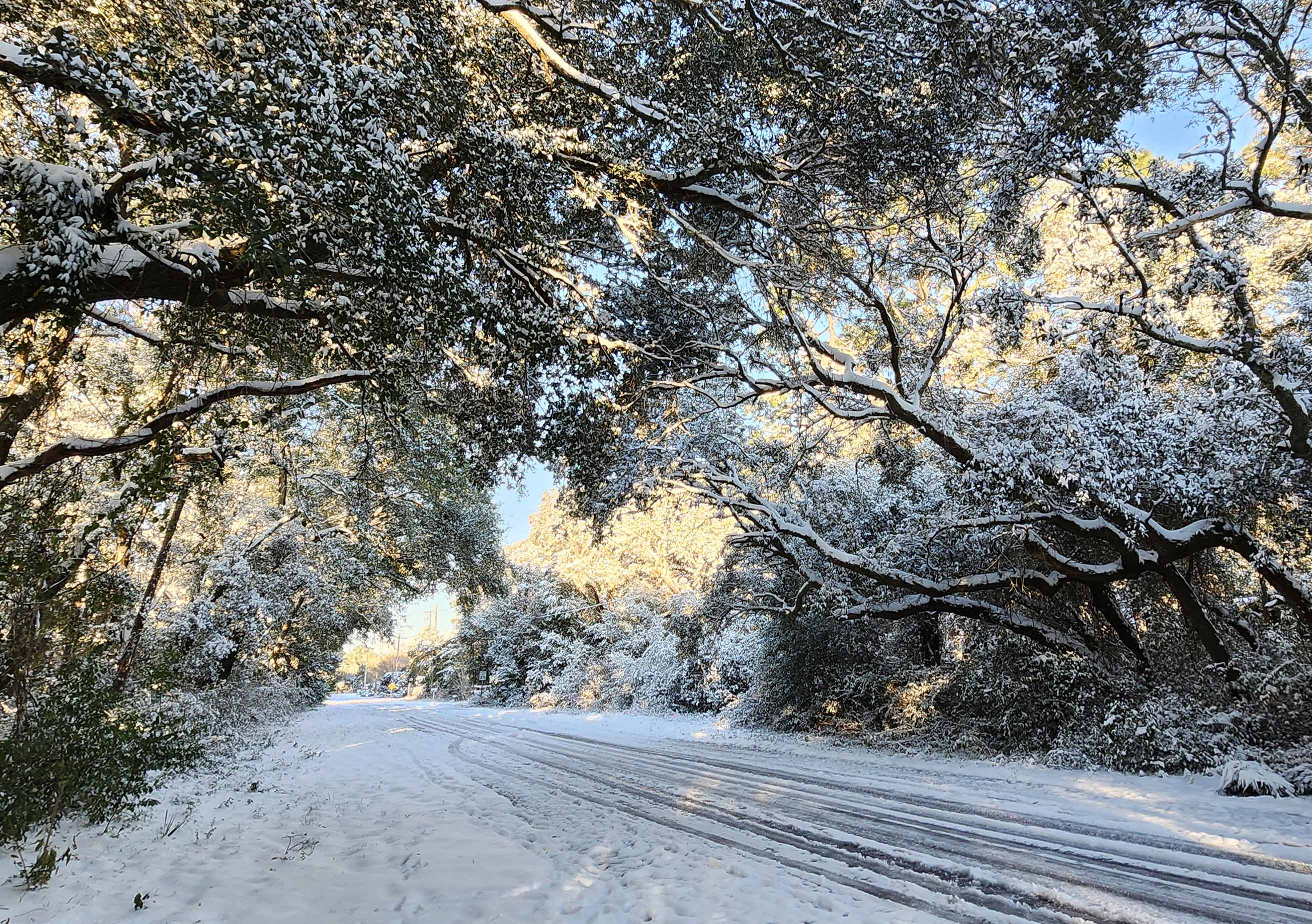
WINTER STORM 2025
Beginning at 9 a.m. on Tuesday, Jan. 21, 2025, the EOC will be at a level 2 partial activation with Emergency Management Staff monitoring storm conditions. Below is the latest information, the most recent posted toward the top.
Read Governor Desantis' EO 25-13, State of Emergency for the State of Florida >>
ROAD INFO
There are multiple ways to receive alerts for the most up-to-date road closure information.
⚫️>>>𝐍𝐈𝐗𝐋𝐄: For any road closure updates, text your zip code to 888777 to receive Nixle alerts.
⚫️>>> 𝐅𝐋𝟓𝟏𝟏.𝐜𝐨𝐦 >> https://fl511.com/
CURRENT ROAD CONDITIONS
__________________________________
*Encourage to avoid
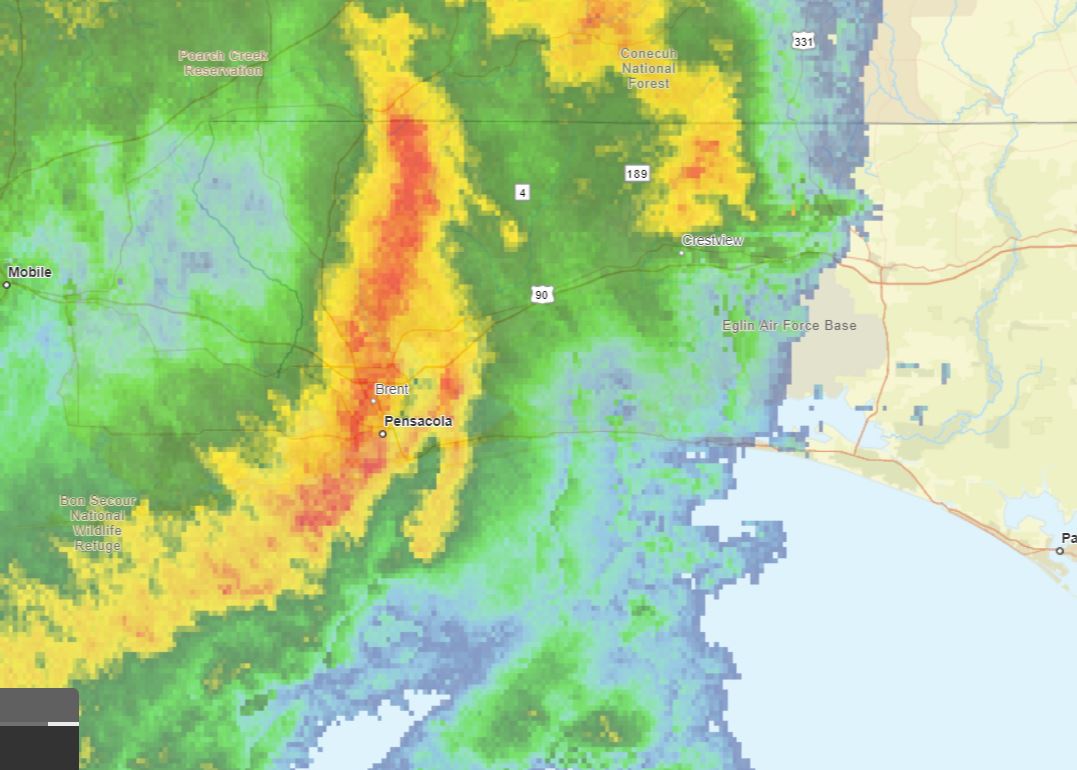
- Stillwell Blvd between Valley Rd. and Brackin St remains impassable and closed
- Hwy 90 (per Sheriff’s Office) ice is spread throughout with frequent blockages
- Hwy 393
- Hwy 4
_______________________________________________________________
Update: Posted Tues. Jan. 21, 2025 - 1:30 p.m.
Our Public Safety staff works around the clock to keep us safe and informed. As the winter weather descends upon us, our Public Safety Director Patrick Maddox wanted to share his thoughts as staff monitors the storm.
𝐺𝑟𝑒𝑒𝑡𝑖𝑛𝑔𝑠 𝑎𝑙𝑙, 𝐴𝑠 𝑤𝑒 𝑏𝑒ℎ𝑜𝑙𝑑 𝑡ℎ𝑒 𝑛𝑎𝑡𝑢𝑟𝑎𝑙 𝑤𝑜𝑛𝑑𝑒𝑟 𝑢𝑛𝑓𝑜𝑙𝑑𝑖𝑛𝑔 𝑏𝑒𝑓𝑜𝑟𝑒 𝑢𝑠, 𝑤𝑒 𝑎𝑟𝑒 𝑓𝑜𝑟𝑐𝑒𝑑 𝑡𝑜 𝑟𝑒𝑚𝑖𝑛𝑑 𝑒𝑣𝑒𝑟𝑦𝑜𝑛𝑒 𝑜𝑓 𝑡ℎ𝑒 ℎ𝑎𝑧𝑎𝑟𝑑𝑠 𝑐𝑟𝑒𝑎𝑡𝑒𝑑 𝑏𝑦 𝑠𝑢𝑐ℎ 𝑎 𝑚𝑖𝑟𝑎𝑐𝑙𝑒- 𝑠𝑝𝑒𝑐𝑖𝑓𝑖𝑐𝑎𝑙𝑙𝑦 𝑟𝑜𝑎𝑑𝑤𝑎𝑦𝑠. 𝐶𝑜𝑛𝑑𝑖𝑡𝑖𝑜𝑛𝑠 𝑎𝑟𝑒 𝑞𝑢𝑖𝑐𝑘𝑙𝑦 𝑑𝑒𝑡𝑒𝑟𝑖𝑜𝑟𝑎𝑡𝑖𝑛𝑔 𝑎𝑛𝑑 𝑐𝑜𝑢𝑛𝑡𝑦/𝑚𝑢𝑛𝑖𝑐𝑖𝑝𝑎𝑙 𝑏𝑟𝑖𝑑𝑔𝑒𝑠 𝑎𝑟𝑒 𝑞𝑢𝑖𝑐𝑘𝑙𝑦 𝑖𝑐𝑖𝑛𝑔 𝑜𝑣𝑒𝑟. 𝐹𝐷𝑂𝑇 ℎ𝑎𝑠 𝑒𝑛𝑔𝑎𝑔𝑒𝑑 𝑖𝑛 𝑟𝑜𝑏𝑢𝑠𝑡 𝑑𝑒-𝑖𝑐𝑖𝑛𝑔 𝑒𝑓𝑓𝑜𝑟𝑡𝑠 𝑤ℎ𝑖𝑐ℎ 𝑚𝑎𝑦 𝑏𝑒 𝑒𝑐𝑙𝑖𝑝𝑠𝑒𝑑 𝑏𝑦 𝑠𝑢𝑐ℎ ℎ𝑒𝑎𝑣𝑦 𝑠𝑛𝑜𝑤𝑓𝑎𝑙𝑙. 𝑊𝑒 𝑚𝑎𝑦 𝑛𝑜𝑡 𝑏𝑒 𝑎𝑏𝑙𝑒 𝑡𝑜 𝑢𝑝𝑑𝑎𝑡𝑒 𝑒𝑎𝑐ℎ 𝑠𝑚𝑎𝑙𝑙 𝑏𝑟𝑖𝑑𝑔𝑒 𝑤ℎ𝑖𝑐ℎ 𝑐𝑙𝑜𝑠𝑒𝑠 𝑖𝑛 𝑟𝑒𝑎𝑙-𝑡𝑖𝑚𝑒 𝑎𝑠 𝑤𝑒 𝑏𝑟𝑖𝑛𝑔 𝑜𝑢𝑟 𝑐𝑟𝑒𝑤𝑠 𝑖𝑛 𝑓𝑜𝑟 𝑠𝑎𝑓𝑒𝑡𝑦, 𝑏𝑢𝑡 𝐹𝐿511.𝑐𝑜𝑚 𝑖𝑠 𝑎𝑛 𝑒𝑥𝑐𝑒𝑙𝑙𝑒𝑛𝑡 𝑠𝑜𝑢𝑟𝑐𝑒 𝑓𝑜𝑟 𝑢𝑝𝑑𝑎𝑡𝑒𝑑 𝑐𝑙𝑜𝑠𝑢𝑟𝑒𝑠 𝑜𝑓 𝑠𝑡𝑎𝑡𝑒 𝑟𝑜𝑎𝑑𝑠 𝑎𝑛𝑑 𝑏𝑟𝑖𝑑𝑔𝑒𝑠. 𝐼𝑓 𝑦𝑜𝑢 𝑑𝑜𝑛’𝑡 ℎ𝑎𝑣𝑒 𝑡𝑜 𝑑𝑟𝑖𝑣𝑒- 𝑑𝑜𝑛’𝑡. 𝑊𝑒’𝑙𝑙 𝑔𝑒𝑡 𝑡ℎ𝑟𝑜𝑢𝑔ℎ 𝑡ℎ𝑖𝑠 𝑡𝑜𝑔𝑒𝑡ℎ𝑒𝑟- 𝑠𝑡𝑎𝑦 𝑤𝑎𝑟𝑚, 𝑎𝑛𝑑 𝑟𝑒𝑝𝑜𝑟𝑡 𝑎𝑙𝑙 𝑢𝑛𝑠𝑎𝑓𝑒 𝑐𝑜𝑛𝑑𝑖𝑡𝑖𝑜𝑛𝑠 𝑡𝑜 𝑙𝑜𝑐𝑎𝑙 𝑎𝑢𝑡ℎ𝑜𝑟𝑖𝑡𝑖𝑒𝑠. - Patrick Maddox, Director of Okaloosa County Public Safety.
Want the most up-to-date road info? There are multiple ways to receive alerts for the most up-to-date road closure information.
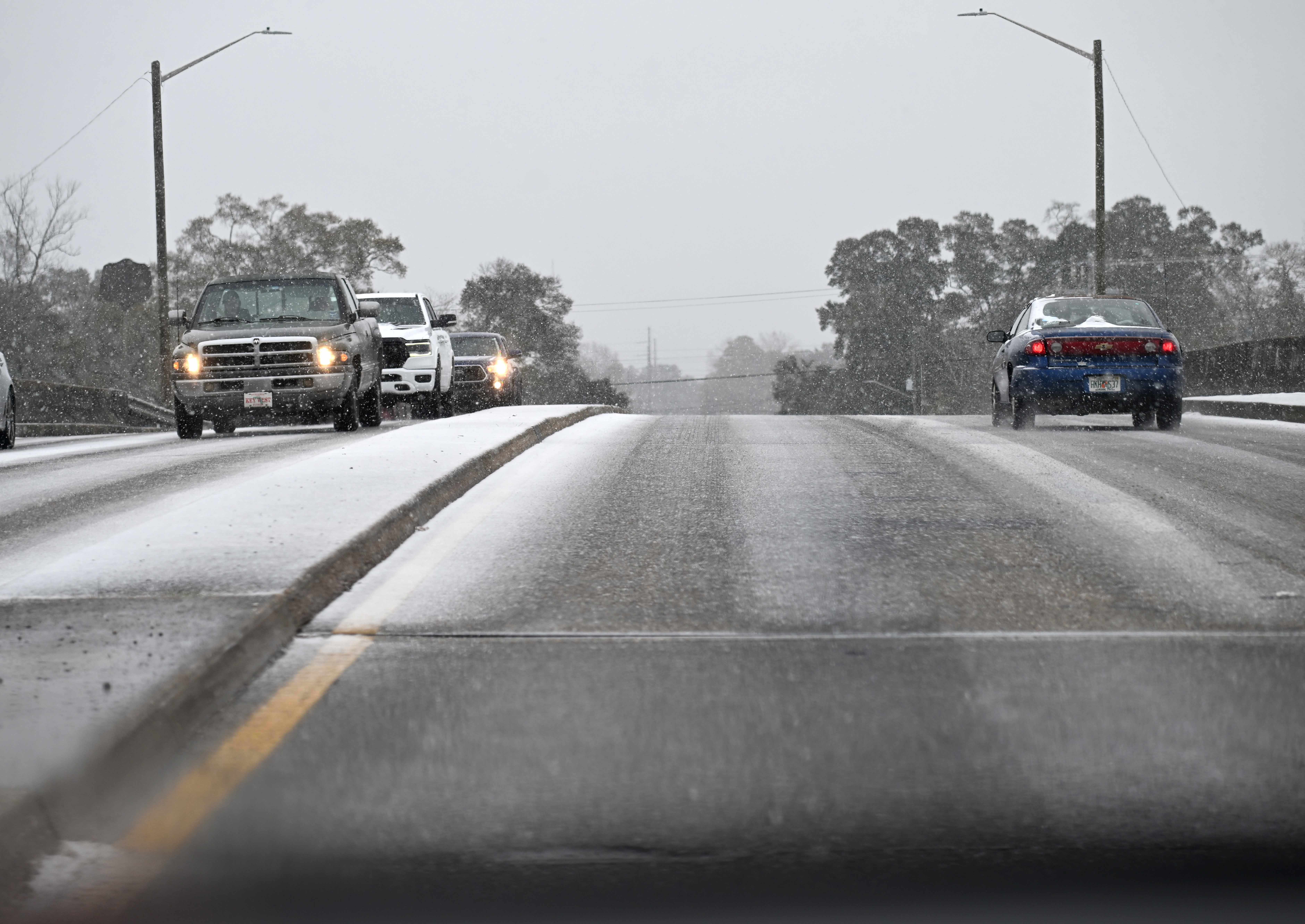
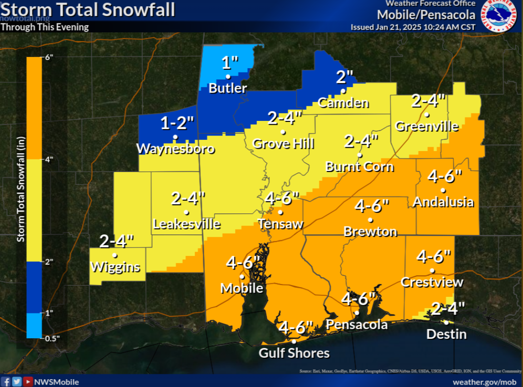
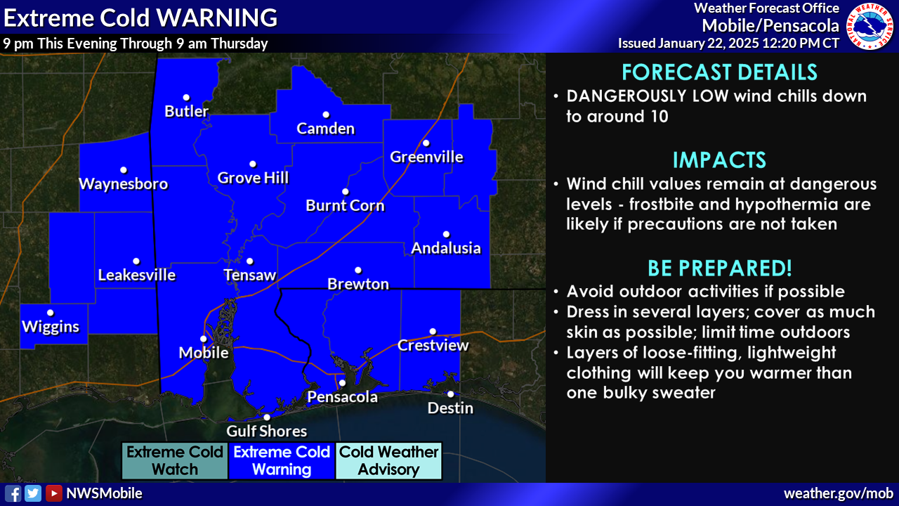
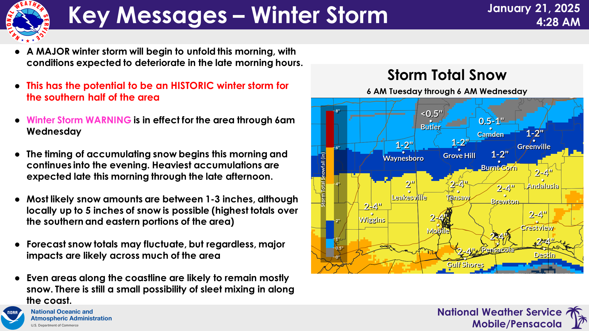
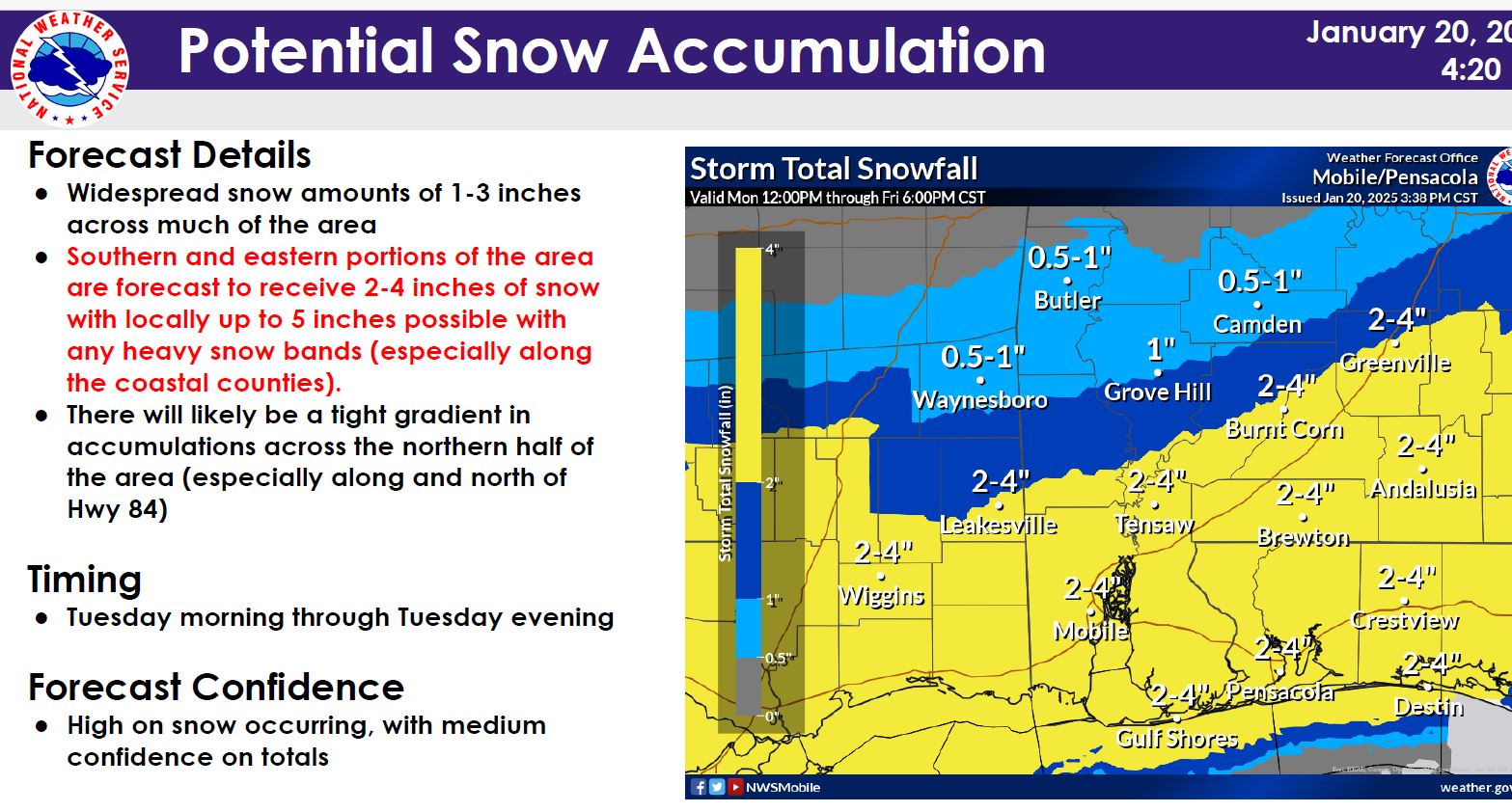
· A potentially historic snow event is possible across the southern half of the area, especially for areas along the coast.
· Major impacts are expected across the entire area, even across locations that receive minor accumulations.
· This event is expected to be primarily snow; however, there could be some sleet that tries to mix in across the FL Panhandle.
· Patchy light snow may start by 6am across southwest Alabama and southeast Mississippi and as early as 9am further east across south central AL and the NW FL Panhandle. The heaviest accumulations are expected late morning through the afternoon.
· Temperatures will drop into the teens and low 20s Tuesday night/Wednesday morning.
· Highs Wednesday will only reach the mid to upper 30s, so it is likely snow/ice on roads and bridges will still be a concern for Wednesday night/Thursday morning.
Mostly clear skies on Wednesday may help to melt some of the snow/ice on area roadways, but any residual moisture will refreeze at night.
____________________________________________________________
Severe Weather Resources:
- National Weather Service in Mobile: https://www.weather.gov/mob/
- Sign up for severe weather alerts: https://alertokaloosa.com/
- Disaster supply checklist: https://www.floridadisaster.org/planprepare/hurricane-supply-checklist/
Click HERE to sign up for local alerts. | DOWNLOAD the current hurricane guide
April 10, 2024
EOC activated at Level 2 (partial activation) beginning 12:00 p.m.
4:25 Update
Overview/What's New: The leading line of storms has exited our area with lingering showers and embedded thunderstorms. A cold front will move through this evening, and another line of storms will move through the area as this front swings through. Based on current observations, the trends, and the hi-resolution guidance, our main concerns heading into tonight are non-thunderstorm winds and the potential for additional flooding. Please see below for specifics on each hazard.
*Impact 1 - Redevelopment of Thunderstorms *
- WHAT: As mentioned above, additional thunderstorms are expected overnight as the line of thunderstorms moves through the area. We do not anticipate these storms becoming severe, though we cannot completely rule it out.
- WHEN: If thunderstorms do redevelop, these would move through fairly quickly between 10 PM and 2 AM, with thunderstorms exiting the area well before daybreak.
- CONFIDENCE: Confidence is low, though latest forecast thinking is that we will not be able to destabilize and any storms will remain elevated.
*Impact 2 - Flooding*
- WHAT: Lingering rain may exacerbate ongoing flooding in areas that receive the heaviest rainfall. The additional development this evening may produce another 1 to 3 inches of rain, though locally higher amounts are possible.
- WHEN: Continuing through the overnight hours
- WHERE: The best chance for flooding will in the southern half of the area and especially along our coastal counties.
- CONFIDENCE: Confidence on additional flooding is low.
*Impact 3 - Non-Thunderstorm Winds*
- Winds will remain breezy through the evening and overnight hours. We have removed the wind advisory for all but our coastal counties. However, there is a potential for non-thunderstorm winds to increase again this evening with the passage of the front. Gusts of 30 to 35 mph are possible.
The coastal and marine impacts have not changed from previous forecasts, and we still have a High Surf Warning, a High Risk for Rip Currents, a Coastal Flood Advisory, and a Gale Warning in effect.
________________________________
3:50 p.m. Update
The NWS has cancelled the tornado Watch for Okaloosa County. Okaloosa Public Safety is now monitoring for any redevelopment potential this evening and the river level forecasts.
______________________
1:40 p.m. Update
The National Weather Service in Mobile has issued a
* Severe Thunderstorm Warning for...
Southeastern Escambia County in south central Alabama...
Southwestern Covington County in south central Alabama...
Okaloosa County in northwestern Florida...
Santa Rosa County in northwestern Florida...
Eastern Escambia County in northwestern Florida...
* Until 230 PM CDT.
*****Okaloosa County non-essential operations are closed for the day.****
Departments which employ essential employees in Public Safety, Corrections, Public Works, Water and Sewer, Airports and other time-sensitive, critical functions will continue to operate a duty schedule determined by their Department Director in order to avoid interruptions in service.
_______________________
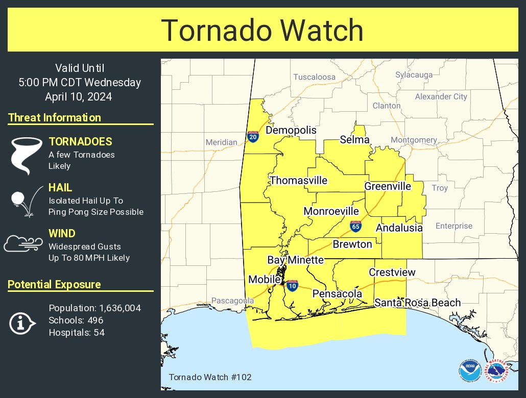
10:24 a.m. Update ( April 10, 2024)
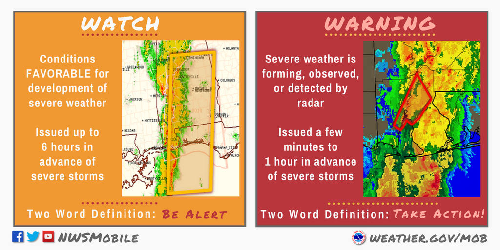
The National Weather Service in Mobile has issued Tornado Watch for portions of northwest Florida from now until 5p.m. This Watch impacts the following locations: Escambia, Okaloosa, and Santa Rosa Counties.
___________________________________
(9 a.m. -Wednesday - April 10, 2024)
Okaloosa Public Safety and NWS Weather Update ( 9 a.m. -Wednesday - April 10, 2024)
Today’s upcoming weather system will bring heavy rains to the area which could lead to flash flooding.
Okaloosa County is closely monitoring the evolving situation in close coordination with the National Weather Service, Florida Division of Emergency Management, strategic partners and neighboring counties. We are not activating risk shelters at this time as school is in session. Please have multiple ways to receive emergency information and monitor official new sources. The Okaloosa County Emergency Operations Center will be activated to Level 2 at noon, staffed with Command-level personnel and our Public Information Officer to assist in operating command and control elements as well as monitoring and disbursing information on the storm and any local impacts.
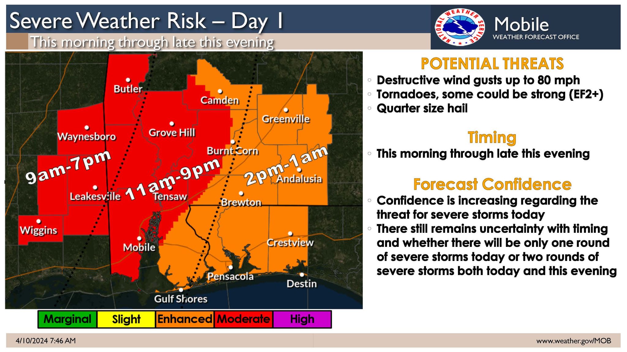
Severe weather is expected but there are two plausible scenarios:
• Scenario #1: A squall-line moves across the forecast area from west to east from mid-morning through late afternoon. In advance of the squall-line, a few discrete supercells will be possible across far southeast Mississippi and potentially as far east as coastal Alabama. Damaging winds up to 80 mph and tornadoes will be possible with any supercell and within the squall-line.
• Scenario #2: The squall-line poses a threat for damaging winds and tornadoes across southeast Mississippi but weakens as it moves into Alabama and transitions to a flood threat north of the I-10 corridor. Across coastal Alabama and the Florida Panhandle, the severe weather threat would be this evening into the overnight hours with a tornado and damaging wind threat.
Sign up for local weather alerts at AlertOkaloosa.com
The latest local severe weather information from the County can be found on social media at https://www.facebook.com/OkaloosaCounty/ or on the County’s EOC website at https://myokaloosa.com/eoc/home
Debris Info as of 9 a .m. April 10, 2024
Unless there is an emergency declaration related to debris recovery, it will be business as usual related to garbage service. Same rules apply to bulk waste and yard trash for routine residential service:
- Yard trash is picked up once a week and should be containerized in bags or cans. If it cannot be containerized it should be placed in bundles, piles, or stacks with sizes no greater than 4 inches in diameter or 6 feet long; and weigh no more than 50 pounds.
- Bulk waste is picked up once a week and includes items such as furniture and appliances. Other bulky items should not amount to more than four cubic yards per pick up.
______________________________________________________
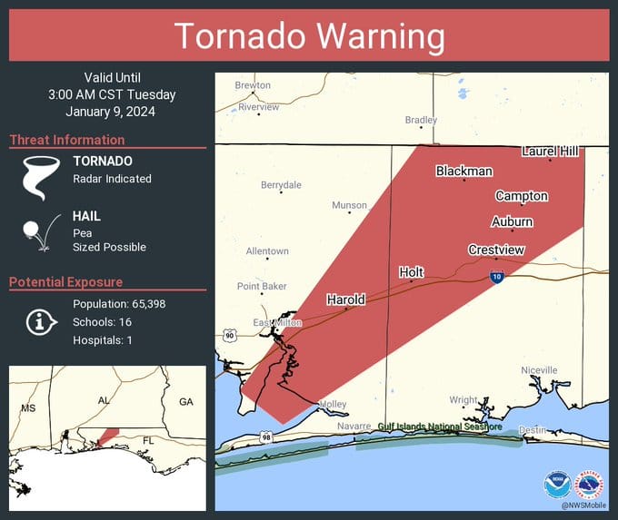
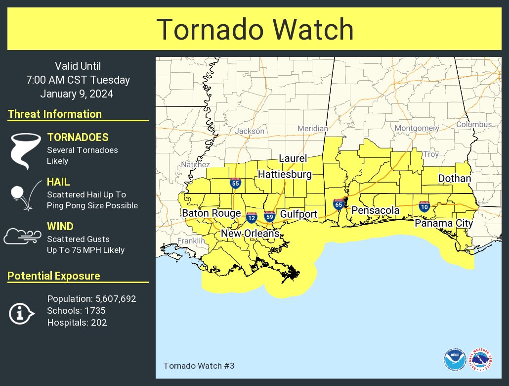
Jan. 9, 2024
EOC activated at Level 2 (partial activation) beginning 12:00 a.m. Jan. 9, 2024
6:30 a.m. - NWS - Tornado Warning until 7 a.m. for portions of Okaloosa County.
______
5:30 a.m. Jan. 9
![]() NWS (Weather.gov/mob): Severe Thunderstorm Warning until 6:30 AM CST
NWS (Weather.gov/mob): Severe Thunderstorm Warning until 6:30 AM CST
The main line of storms is now entering Florida, moving East. Very quick tornadic spinups have occurred in this system with 70MPH straight-line winds embedded in the line. We’re hoping that the line is East of Okaloosa County by 7:30-8AM. Take appropriate precautions now.
Per OCSO as of 5:43 a.m. Hwy 285 is back open.
Per OCSO: Hwy 285 at State Road 293 completely shut down for road debris from the storm.
2:45 a.m.
Jan. 8, 2024 (9:06 p.m)
🌪️A tornado watch has been issued for parts of Alabama, Florida, Louisiana and Mississippi until 7 AM CST 01.09.2024.
____________________________________
Jan. 8, 2024 ( 2:30 p.m.)
Okaloosa County will be activating the Emergency Operations Center at midnight, Jan. 9, 2024, to a modified Level 2 (partial activation) in preparation for potential severe weather that is forecast to impact the County. Emergency Management staff will be monitoring the storm system that is expected to bring sustained winds of 25-30 mph with possible gusts above 70 mph.
Additionally, County administrative offices will be opening on a delayed start on Tuesday, January 9, to ensure the safety of employees during potentially hazardous conditions in the morning. Departments deploying essential personnel will follow a schedule set by the Department Director to maintain continuity of operations.
The main line of storms is expected to arrive between 6- 7 a.m. on Tuesday and clear by 9 a.m. Heavy rainfall of 2-3 inches is forecast with the possibility of tornadoes.
Residents are encouraged to take this system seriously and make preparations that include securing loose debris around the home, having multiple ways to stay informed, and being prepared for the possibility of power outages.
The latest local severe weather information from the County can be found on social media at https://www.facebook.com/OkaloosaCounty/ or on the County’s EOC website at https://myokaloosa.com/eoc/home
April 5-6, 2022
4.6.22 3pm:
The NWS is keeping us in the Slight Risk category for any storms which are able to fire this afternoon and evening. So far not much activity, but we will continue to monitor. There’s plenty of MLCAPE (instability in the atmosphere) but not a ton of deep level shear at the moment so the tornado risk is quite a bit lower than yesterday. This type of set up favors gusty winds and hail if the storms are able to sustain themselves. As the cold front approaches there is an opportunity for the deep level shear to increase, so we’ve got our eye on it. Overview/What's New: There remains the possibility of isolated severe thunderstorms this afternoon and evening with large hail and damaging wind gusts the main threats.
- WHAT: Isolated severe storms capable of producing large hail and localized damaging wind gusts.
- WHEN: This afternoon and evening.
- WHERE: There is a Slight Risk across most of the region, with the exception of a Marginal Risk across parts of inland SE MS.
- CONFIDENCE: Low
4.5.22 - 2p.m.
4.5.22 - 1:40 p.m.
The National Weather Service In Mobile Has Issued A
* Flash Flood Warning For...Southeastern Okaloosa County In Northwestern Florida...* Until 745 Pm Cdt Tuesday.
* At 137 Pm Cdt, Doppler Radar Indicated Thunderstorms ProducingHeavy Rain Across The Warned Area. The Expected Rainfall Rate Is 1
To 3 Inches In 1 Hour. Additional Rainfall Amounts Of 1 To 4 Inches Are Possible In The Warned Area. Flash Flooding Is OngoingOr Expected To Begin Shortly.
Impact...Flash Flooding Of Small Creeks And Streams, uban Areas, highways, streets and underpasses as well as Other Poor Drainage And Low-Lying Areas.
* Some Locations That Will Experience Flash Flooding Include...Wright, Fort Walton Beach, Niceville, Destin, Eglin Afb, Valparaiso, Mary Esther, Lake Lorraine, Ocean City, Shalimar,
Cinco Bayou, Eglin Village, Longwood, Postil And Seminole.
4.5.22 - 1:30 p.m.
The National Weather Service in Mobile has issued a
* Severe Thunderstorm Warning for...
Southern Okaloosa County in northwestern Florida...
Southeastern Santa Rosa County in northwestern Florida...
* Until 200 PM CDT.
* At 120 PM CDT, severe thunderstorms were located along a line
extending from 5 miles south of Crestview to 3 miles northeast of
Navarre Beach, moving east at 45 mph.
HAZARD...70 mph wind gusts.
SOURCE...Radar indicated.
IMPACT...Expect considerable tree damage. Damage is likely to
mobile homes, roofs, and outbuildings.
* Locations impacted include...
Wright, Fort Walton Beach, Niceville, Destin, Eglin AFB,
Valparaiso, Mary Esther, Ocean City, Lake Lorraine, Shalimar, Cinco
Bayou and Navarre Beach.
PRECAUTIONARY/PREPAREDNESS ACTIONS...
A Tornado Watch remains in effect until 200 PM CDT for northwestern
Florida.
For your protection move to an interior room on the lowest floor of a
building.
A Tornado Watch remains in effect until 200 PM CDT for northwestern
Florida.
4.5.22 - 12:30 p.m.
The northwestern areas of the County will be impacted by the storm system shortly, followed by the remainder of the county from NW to SE as the line passes through.
Watches/Advisories
-Tornado Watch in effect until 2 p.m.
-Severe thunderstorm warning until 1:15 p.m. (60 mph gusts - radar indicated)
-Wind Advisory in effect until 6 p.m. (sustained winds 15-25mph with gusts of 40 mph or more)
-Small craft advisory
-Gulf water is closed for swimming (double red flags are flying at the beach)

4.5.22 8:30am SEVERE WEATHER UPDATE - There are no changes to the impacts for Today's event. There is a slight adjustment to delay the squall line timing by a couple of hours, and extend the timing through 6pm. We still expect two rounds of severe weather today and those details are broken down in the bulleted points below. A Tornado Watch is now in effect for the entire area until 2pm. Additional watches will be possible later today. A High Surf Advisory has been issued for this Afternoon and Evening for expected breaker heights of 5 to 6 feet. Minor coastal flooding is still a possibility in the northern portion of Mobile Bay in the mid to late afternoon hours (potentially impacting the Causeway near the eastbound I-10 onramp). A High Risk of Rip Currents persists through Thursday.
- WHAT: Two rounds of severe weather are expected with today's event. The first round of severe storms will be the ongoing supercells ahead of the squall line as a warm front continues to move northward. Damaging winds, fast-moving tornadoes (a few strong tornadoes possible), and large hail are all possible with these supercells. The second round of severe storms will be associated with the squall line. Damaging winds up to 70mph and fast-moving tornadoes are possible with the squall line. Flash flooding is possible (especially across urban areas, flood-prone areas, and our typical low-lying spots) as these storms will be capable of producing 1-3 inches of rain in a short period of time.
- WHEN: The ongoing supercell development across southeast Mississippi and parts of southwest /south-central Alabama will continue throughout the morning into the early afternoon hours ahead of the squall line. The supercell development is expected to expand further southeast to include the western Florida Panhandle by late this morning. Based on the latest guidance, the squall line should enter our southeast Mississippi counties around 9am and should be nearing the I-65 corridor by 1pm. The line will likely be exiting our northwest Florida counties around 6pm. Flooding remains a concern throughout the day, but especially as the squall line slides across the area. (Note: the timing listed on the severe map reflects the entire window of concern for both the supercells and squall line.)
- WHERE: All of southeast Mississippi, southwest Alabama, south-central Alabama, and northwest Florida.
- CONFIDENCE: Confidence remains high in both rounds of severe weather today.
3.30 - 3.31.22
3:05am Now that the storms are leaving the area, morning commutes approach in the next couple of hours and the tornado watch is canceled, we want to be sure to remind everyone to avoid driving over water flowing over the roadways. Use caution. There will be standing water over low-lying areas. Avoid downed power lines. Assume all lines are live. Call 911 if one is discovered. We hope everyone stayed safe overnight. We will share relevant updates on major damage and/or flooding reports. If you sustained storm damage, please report it here: https://survey123.arcgis.com/share/8ce4fbeca4a34dc58a12d40bdd4866f1
1:45am Severe Thunderstorm Warning
**1:30am update** Significant winds up to 70 mph or greater will impact Crestview, FL area. Take cover now.
1:20pm Severe Thunderstorm Warning until 2:15 AM CDT for Okaloosa County, FL, Santa Rosa County, FL, Escambia County, FL. More information.
TORNADO...POSSIBLE
THUNDERSTORM DAMAGE THREAT...CONSIDERABLE
MAX HAIL SIZE...1.00 IN
MAX WIND GUST...70 MPH
1:15 pm **Update** Intense rotation with likely tornado is moving through Floridale now and will be heading northeast rapidly. This may produce a strong tornado and impact Kellys Mill to Baker, FL. Take cover immediately as this is a potentially very dangerous storm!
1pm Heavy stuff in bound. Lots of hail and rotation in Santa Rosa County storms moving East into Okaloosa.
12:45am Tornado Warning until 1:30 AM CDT for Okaloosa County, FL, Santa Rosa County, FL. More information at https://inws.ncep.noaa.gov/a/a.php?i=67897140
12:19 am Severe Thunderstorm Warning
10:30pm We were live around 10:30 pm at the Okaloosa County Emergency Operations Command Center with Public Safety Director Patrick Maddox for a severe weather update.
10pm We've just finished a safety briefing and expect to start feeling the effects of the rough weather around 11pm. We are still some time away from the impact of the squall line and continue to experience gusty conditions with sustained winds around 20MPH. Many of the storms are moving at 50+ MPH, so keep weather-aware.
7:30pm Severe Weather Update. Our area is under a Tornado Watch until 4am. Here's a snap shot of the severe weather system setting up to our West. There have been numerous tornadoes and wind damage reports associated with the system. We are still hours away from the main impact and will continue to provide updates. Monitor warnings at https://bit.ly/3DotTT5WeatherWarnings Other advisories include:
- Rip Current Statement until April 2, 06:00 AM CDT
- Wind Advisory until March 31, 12:00 AM CDT
- High Surf Warning until March 31, 06:00 PM CDT
- Coastal Flood Advisory in effect from March 30, 03:00 PM CDT until March 31, 06:00 AM CDT
- Tornado Watch in effect from March 30, 06:35 PM CDT until March 31, 04:00 AM CDT
11:30am Okaloosa County Public Safety Director, Patrick Maddox has completed a call with National Weather Service and Florida Division of Emergency Management. Here's what we know about tonight's rough weather:
- No great changes to our expected impacts in Okaloosa. The timing has slowed just a little bit on arrival of the storm line (12AM instead of 11PM) but the exit time of 5AM still holds due to the fast-moving nature of this system.
- The weather expected to impact our area during this event will be dangerous, placing the entire forecast area in the “Moderate Risk” category. This will be a fast moving system with the capability of delivering gusts to 80MPH within stronger thunderstorms, and producing strong, fast-moving rain-wrapped tornadoes with little time to react. Some of these strong tornadoes could be long-track, remaining on the ground for extended periods. Ahead of the main storm line we are not expecting wide-spread supercell development, but strong southerly winds of 20-30MPH, gusts to 55MPH throughout this afternoon are likely.
- We are already seeing the winds increase and are flying double red flags oat the beach (Destin as well). Surf heights will quickly increase to the 9’-12’ range throughout the day today with associated dangerous rip currents and dangerous back-break. Some minor coastal flooding of 1-2 feet is possible.
- Rain totals in the 1-3” range are likely with some locally higher amounts in areas where storms travel repeatedly. Heavy downpours are possible, but the system will be moving so quickly that flash flood threats are limited. The current expectation is that the system will be clear of our area between around 5AM Thursday, but there is always room for adjustment there based upon exact storm evolution.
- The Emergency Operations Command Center will activate to Level 2 at 5PM this evening with Command Staff and limited Sections/Branches staffed. We will remain at the EOC through the overnight hours to coordinate county response to the threat.
- An Everbridge (Alert Okaloosa) notice was sent to Okaloosa County residents last evening at 5PM to give adequate time to prepare and react. Didn't get a message? Click here to sign up for Alert Okaloosa Emergency Messages: https://bit.ly/3ksJhmtAlertOkaloosa.
- We will continue to update as necessary, keep an eye on https://www.weather.gov/mob/ for the latest developments in this weather event.
10am: Double Red Flags. water is closed
FOR MORE INFORMATION CLICK HERE TO SIGN UP FOR ALERTS
3.22.22 10am
3.21.22 9:20pm
3.18.22 4:30pm
3.18.22 1:15pm
3.18.22 - 11:47am
3.18.22 - 10am
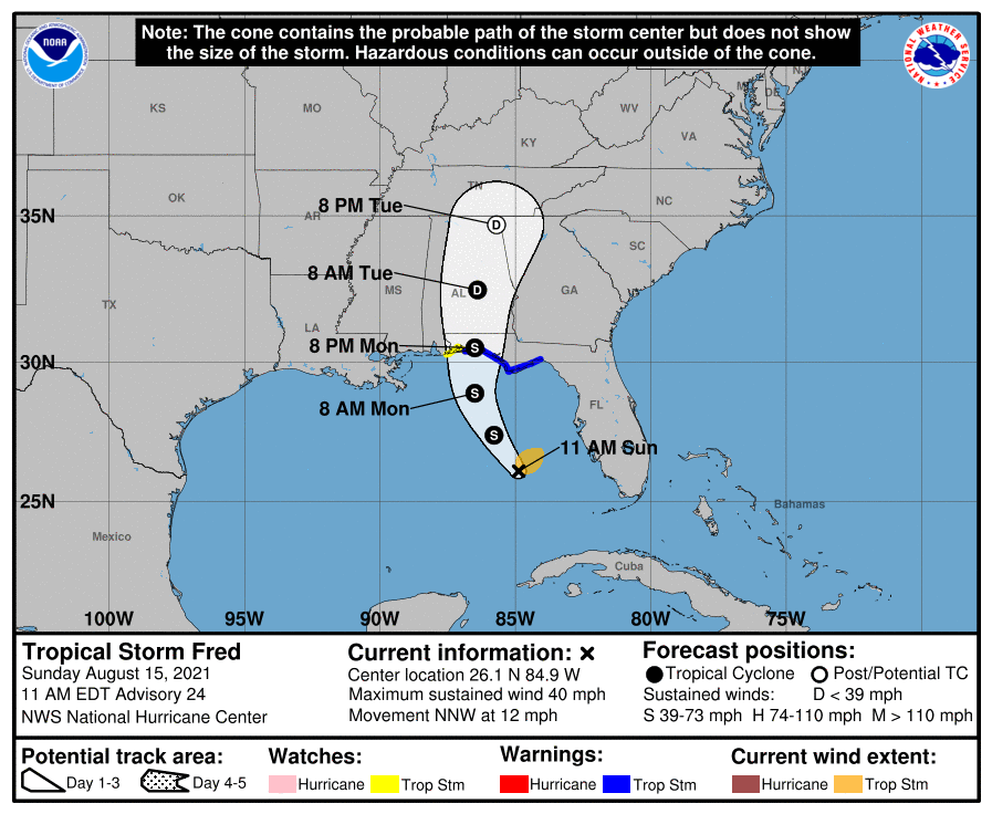
Tropical Storm Fred
Click HERE to sign up for local alerts | DOWNLOAD the Hurricane Guide
August 16, 2021
4pm TROPICAL STORM FRED made landfall near Cape San Blas about an hour ago with max sustained winds of 65 MPH and is now moving North/Northeastward with winds of 60 MPH. The storm has come as far West as it was going to go and is peeling away from Okaloosa County.
Noon Live Update with Public Safety Director Patrick Maddox
11am Tropical Storm Fred (Monday midday update) from Okaloosa County Public Safety, National Weather Service and National Hurricane Center. Tropical Storm conditions are beginning now, surge warnings from Indian Pass to Yankee town 3-5 feet (East of our area), 1-3 feet for us (also diminishing since high tide has passed), 2-4” rain throughout the county which is a nice shift downward. Fred is expected to be a strong Tropical Storm at landfall. The threat of sustained tropical storm force winds is decreasing, but gusts to tropical storm force (mostly 25-35MPH) are certainly possible.
◾Rain: 3-4" of rain forecast ◾On the forecast track, the center of Fred should make landfall in the eastern Florida Panhandle this afternoon or early this evening, and move over western Georgia on Tuesday. ◾Wind gust of 25-35 possible beginning this afternoon through this early to mid this evening (mostly gusts) ◾Surf heights to build between 6-9 feet. ◾Bridges: FDOT and local law enforcement consider closing bridges only when sustained winds reach 40 mph
National Hurricane Center 10 a.m. Fred information:
- LOCATION ABOUT 55 MI SW OF APALACHICOLA FLORIDA
- MAXIMUM SUSTAINED WINDS 60 MPH
- PRESENT MOVEMENT N OR 10 DEGREES AT 10 MPH
- MINIMUM CENTRAL PRESSURE 993 MB
10:30 - TURN AROUND DON’T DROWN - While we may see some elevated sustained winds, our area of greatest concern is going to be ponding water and flash flooding as rain bands make their way onshore. 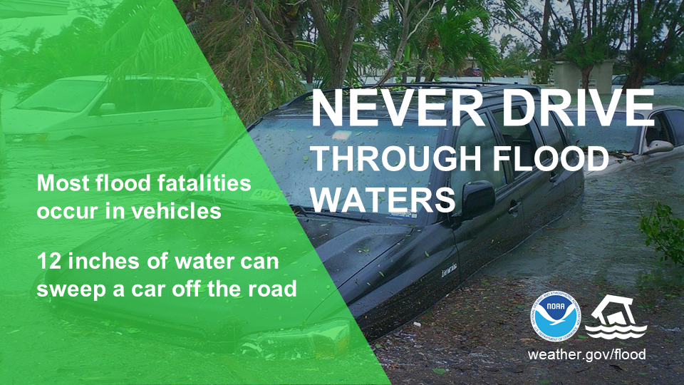 DO NOT DRIVE THROUGH FLOODED OUT AREAS. STAY INDOORS DURING DOWNPOURS. County offices are closed. Courts are closed. Schools are closed.
9:30am - Double Red Flags on Okaloosa County Beaches. Stay Completely out of the water. Follow local alerts and advisories at AlertOkaloosa.com.
8:30am - TROPICAL STORM FRED UPDATE (Monday 8:30 a.m.) Tropical Storm Fred has intensified and is tracking further east of Okaloosa County. This is again beneficial for Okaloosa and nudges tropical storm force wind probabilities and rainfall down a bit. 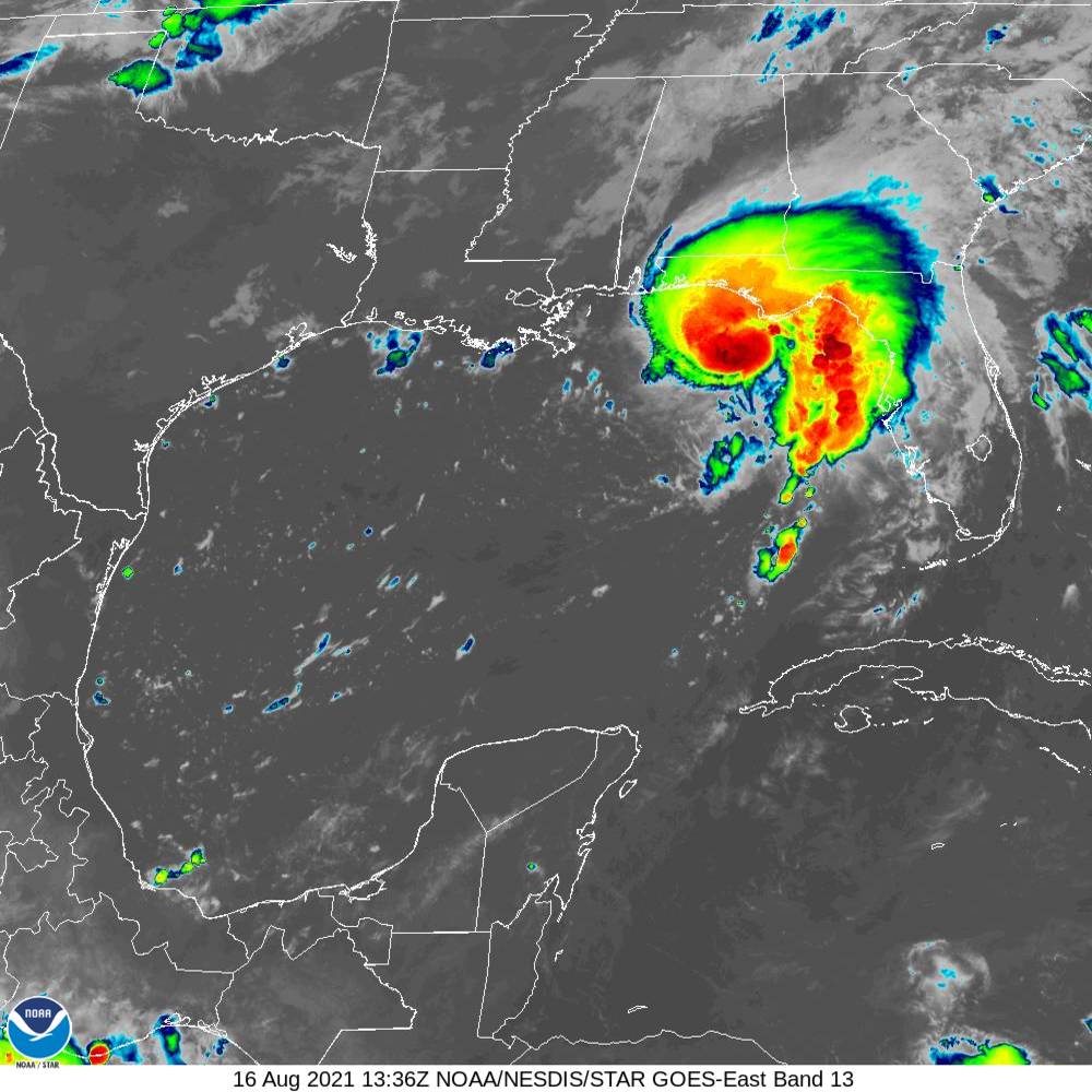
Data from an Air Force Reserve Hurricane Hunter aircraft indicate that Fred is intensifying this morning, and now has maximum sustained winds near 60 mph with an estimated minimum central pressure of 993 mb, according to the National Hurricane Center. A Storm Surge Warning and Tropical Storm Warning is still in effect for the Panhandle to include all of Okaloosa County. 7:30 a.m. data from NHC: LOCATION ABOUT 80 MI SSW OF APALACHICOLA FLORIDA - MAXIMUM SUSTAINED WINDS 60 MPH - PRESENT MOVEMENT N OR 10 DEGREES AT 10 MPH - MINIMUM CENTRAL PRESSURE 993 MB
Remember to stay tuned to local media. We'll provide regular updates. The following are great sources for weather news: - weather.gov/mob - https://www.nhc.noaa.gov/ - https://alertokaloosa.com/
August 15, 2021
7:30pm Tropical Storm Fred update. Jogs to the east place landfall near the Walton County/Bay County line. This brings us out of the highest rainfall values and places us in the 3-6” range if this track holds. This is beneficial for us in many ways, but flash flooding/minor urban flooding can still occur based on rainfall rate alone.
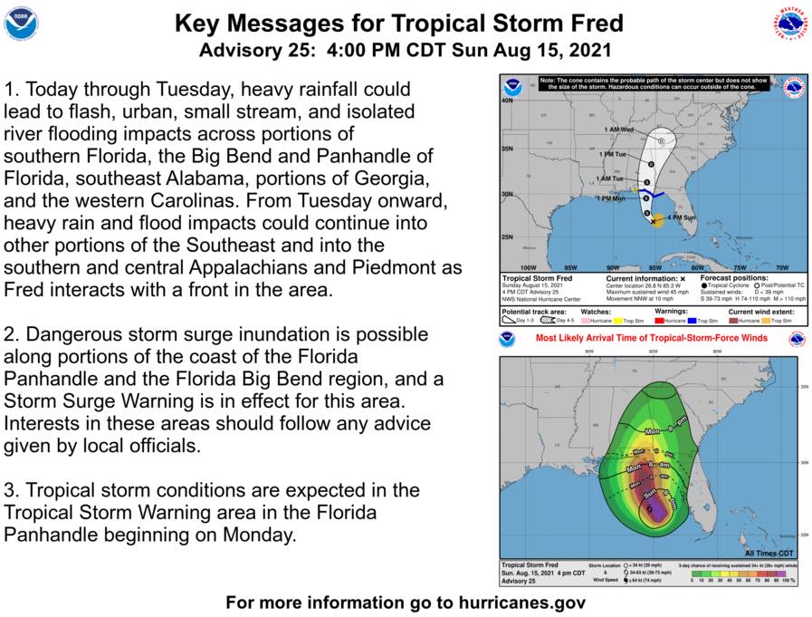
Moderate flooding along the Blackwater and Shoal Rivers is still forecast for Tuesday and Wednesday. We still expect to see some tropical storm force winds throughout the county, mainly along the coast, but gusts to that strength are certainly possible in the North end as well. Any attempt at more organization may allow Fred to wrap more moisture immediately around its core which could change those values some. Storm surge remans at 1-3 feet for our area. Our Local State of Emergency is executed, schools are closed tomorrow AM in an abundance of caution as roadway conditions and unknown bridge status depending on wind are concerns. Risk shelters and evacuations are not anticipated at this time, though a special shelter is on standby for any river evacuees if necessary. Only those designated as essential county employees are to report to work tomorrow. Contact your supervisor if you have questions on the designation of your position. EC Rider has suspended regular bus service tomorrow. Tropical Storm Grace is right behind Fred, but at least for the moment, seems to be staying South. We will monitor closely.Stay tuned for further and monitor hurricanes.gov.

◾A Tropical Storm Warning is now in effect for the coast of the Florida Panhandle from Navarre to the Wakulla/Jefferson County line which includes all of Okaloosa County.
◾ Get prepared for this storm with resources in this link: https://business.facebook.com/1545370005699157/posts/3116989405203868/
The track shifted farther east with landfall now projected in Okaloosa County on Monday evening. Although the chances for tropical storm force winds have risen into the 56%-61% range, the chances for experiencing the heaviest rainfall are decreasing some, with much of the county in the 4-6” range and the eastern third in the 6-8" range. These values can change with track adjustments. Earliest estimated arrival of tropical storm winds, if they were to occur, would be 6 a.m. Monday morning, but changes in the track can push that timing north or south as well. Only minor coastal flooding of 1-3 feet is forecast, but the potential for flash flooding exists with rapid rainfall. Fred is still forecast to a 50 mph tropical storm upon landfall.
◾A Storm Surge Warning has been issued for the coast of the Florida Panhandle. Surge of 1-3 feet is expected.
◾Sandbags available at the following locations while supplies last: -714 Essex Road in the Ocean City-Wright area at Stillwell Park -1759 South Ferdon Boulevard – access off of Goodwin Avenue across from the fuel tanks
◾Bridge closures can be expected when sustained winds exceed 39 mph and closures will be decided by FDOT and local law enforcement.
NHC 10 a.m. storm status update: - ABOUT 335 MI SSE OF PENSACOLA FLORIDA - MAXIMUM SUSTAINED WINDSn40 MPH - PRESENT MOVEMENT NNW AT 12 MPH - MINIMUM CENTRAL PRESSURE 1008 MB. Remember to stay tuned to local media. We'll provide regular updates. The following are great sources for weather news:
- weather.gov/mob
STORM KIT: Be sure you have a storm kit prepared. The first 72 are on you, meaning that you should have prescriptions, water, food, don't forget the pet food, batteries and flashlights. It doesn't take a major hurricane to cause an impact to our modern necessities. View a full list of storm kits items at: https://myokaloosa.com/ps/severe-weather/supply-kit SANDBAGS (While supplies last) Okaloosa County Public Works will make sandbags and sand available for self-serve pick-up beginning at 8 a.m. Friday August 13 at the following locations:-714 Essex Road in the Ocean City-Wright area at Stillwell Park-1759 South Ferdon Boulevard – access off of Goodwin Avenue across from the fuel tanks. The sites will be accessible 24 hours a day while supplies last or until the threat of the storm has passed. Should you have any questions regarding the location of the sandbag sites, please feel free to contact Public Works at 850-689-5772.LAWN FURNITURE. DEBRIS. TRASH.Now is a great time to find a safe shelter for patio and lawn furniture... Actually, anything you'd like to keep from blowing around risking danger to family and property. Looking to pitch in a little more to help others? Visit http://myokaloosa.com/bcc/leavenotrace to find community-organized cleanup efforts.We hope you’ve prepared in advance for hurricane season as placing yard debris on the curb in advance of a storm is not a good plan. Placing excessive yard debris or bulk waste on the curb days before a weather event can cause hazardous objects to blow around.
For more information on how to prepare, CLICK HERE to download our hurricane guide.
FOR MORE INFORMATION CLICK HERE TO SIGN UP FOR ALERTS